Burke Mountain Summit
Rating: very strenuous
Time Needed: 10-12 hours
Length: 23 km
Elevation gain: 1,600 m
Burke Mountain has two summits. The smaller South Summit (otherwise known as Dennett Peak) is the smaller of the two peaks. The North Summit is slightly higher and provides spectacular 360-degree views.
This week’s route can be cut short by four to five hours by turning back for home at the South Summit, but that means missing out on the best of the viewpoints.
The route between the two summits is rough and in places hard to follow, and is recommended only for experienced hikers.
From the entrance to the Gun Club on Harper Road, head up the main gravel road to the right. Pass by the first turning on the left and then, shortly afterwards, take the next turning on the left. This is the continuation of Harper Road. Follow this for about 2 km, ascending gradually until just before a hairpin bend, where there is a green gate. Just before the green gate, there is a track heading off to the left. Follow this track for about 200 m and then take the path on the right just after crossing Pritchett Creek.
Now, following the South Slope Trail upwards, you will shortly come to the site of the old bulldozer. The trail will soon leave the banks of Pritchett Creek and flattens out prior to crossing Coho Creek. This creek crossing can be dangerous when there is high water flow, so consider using the alternative crossing upstream if this is the case.
Another half a kilometre of gentle uphill will bring you out at Lily Pad Lake, the first of several picturesque mountain tarns on the upper Burke Plateau. Just after Ted Kay Lake, there will be a couple of paths heading off on the right. The first of these connects with the very top of Harper Road, providing an alternative (but slightly longer) route home. The second heads down to Dennett Lake.
Continue up the main trail through subalpine meadows, passing a viewpoint after about a kilometre. The South Summit is about 2 km from Ted Kay Lake on a little side trail to the right. The views from the top are somewhat obscured but a better viewpoint can be found (looking over to Coquitlam Mountain) just to the north of the summit trail spur.
Although the route to the North Summit doesn’t look far on the map (2.3 km), the return journey from this point will take four to five hours due to the trickiness of the terrain. If you are running short on time or are not confident navigating flag to flag on indistinct “trails,” then this will be the time to head back for home.
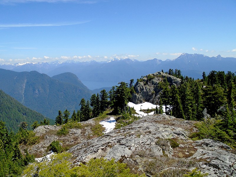
For the more adventurous, the trail heads north down to a col, and then up again as it skirts the eastern flanks of Pika Peak. There’s another drop before the ascent to the North Summit, and you will eventually emerge onto a broad ridge with fine views.
For even better views, follow the flagged route southwest to a magnificent rocky platform with 360-degree views. Expect some bushwhacking and easy scrambling to reach the viewpoint, and plan to spend some time here taking in views of Golden Ears, Mount Robbie Reid, Pitt Lake/River, Widgeon Peak and Coquitlam Mountain.
Your route down will retrace your upward route, unless you choose to take the Burke Ridge Trail to Harper Road for a bit of variety.
Steve Chapman is a Coquitlam Search and Rescue volunteer, a member of the Burke Mountain Naturalists and the creator behind a detailed new map of Tri-City trails. More info on safe hiking: www.coquitlam-sar.bc.ca.


