Hike of the Week: Coquitlam Lake Viewpoint
Rating: strenuous
Time Needed: 6 to 7 hours
Length: 14 km
Elevation gain: 680 m
This hike takes in some of the best that Burke Mountain has to offer — no fewer than four waterfalls and a spectacular viewpoint overlooking Coquitlam Lake, Eagle Ridge, Vancouver Island and the forbidden lands of the Coquitlam watershed. The elevation gain and distance also make this hike a good workout.
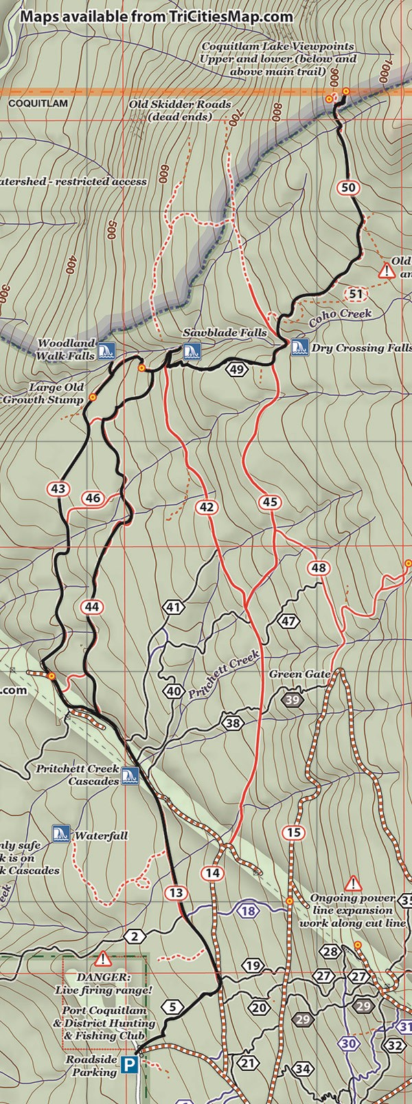
Start the hike at the end of Harper Road by the entrance to the gun club, taking a mountain bike trail up on the left from where the yellow gate is (watch out for mountain bikers coming down and give them room).
Where the trail reaches a track at the top, turn left and follow the Woodland Walk for about a kilometre until it merges with the BC Hydro service road. The views open up nicely here to the northwest as you follow the road for about 700 m over a bridge. The bridge is the site of the first waterfall, quite often a miserable dribble over excavation debris.
Just before the service road turns steeply down near its end, look up for a trail on the right above the road rubble. Climb the rubble to gain the well-marked continuation of the Woodland Walk. Follow this over streams, past a crazy mountain bike jump and a massive old tree stump to the next waterfalls.
When confronted with splits in the trail keep to the left options. The Woodland Walk Falls are much more of a sight than the previous falls and a better view can be had by climbing down the very steep side trail to the base. Be careful on the slippery rocks at the bottom.
Continue up steeply on the main path to emerge in about 15 minutes at a clearing with some nice views through the gap in the trees. Continuing from this viewpoint, you will soon arrive at a fairly indistinct T junction. The trail going right is the upper part of the Woodland Walk Loop. This will be your return route but, for now, take the left branch, which will bring you onto a track. Head left on the track and then up a path that takes you to Sawblade Falls. These falls are easily the most spectacular on the mountain and are featured on the front cover of Lyle Litzenberger’s book Burke and Widgeon — A Hiker’s Guide.
Retrace from the falls and then follow the Sawblade mountain bike trail up to another track at the top. Turn left on to this and cross the creek below the last waterfall of the hike. Shortly after the creek, take the new Coquitlam Lake View Trail up into the trees, following this all the way up to one final partially overgrown track at the top. Head north on this for about 600 m, looking out for a very steep trail on the right that takes you up to the viewpoint — the highlight of the walk. The viewpoint is on a small rocky outcrop that has steep drop-offs, so be careful near the edge.
Return via the same way. A nice alternative return option is to take the upper loop of the Woodland Walk, which is signposted from the junction described earlier. This brings you out on the BC Hydro service road about 300 m north of the bridge.
Steve Chapman is a Coquitlam Search and Rescue volunteer, a member of the Burke Mountain Naturalists and the creator behind a detailed new map of Tri-City trails. More info on safe hiking: www.coquitlam-sar.bc.ca.


