HIKE OF THE WEEK
Golden Ears
Rating: extremely difficult (full route)
Time needed: 12 to 15 hours
Length: 23 km
Elevation gain: 2,125 m
Situated in Golden Ears Provincial Park, Golden Ears towers above other mountains in the Tri-Cities area. To attain the summit requires a major effort, even for experienced and fit hikers, but the 360-degree panoramic views make it worth it.
To complete the whole hike in a day will probably mean starting or finishing in the dark, necessitating the use of that head lamp you always carry in your pack.
To make the hike easier, it can be split into multiple days, with good camping options at Alder Flats and Panorama Ridge. Panorama Ridge itself makes a worthwhile objective, cutting three hours off the total hike and avoiding the tricky scrambling to the summit.
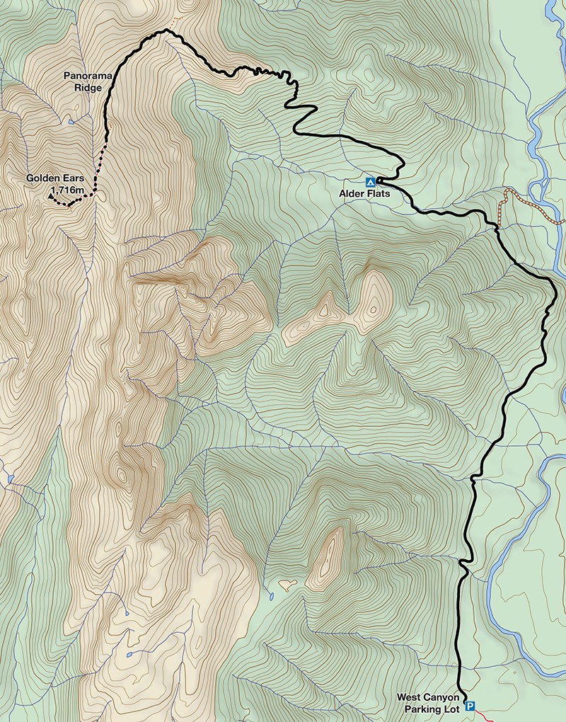
From the West Canyon parking lot, take the West Canyon Trail north. The trail is easy and wide to start, and although it does narrow and undulate further on, the going is generally quite easy.
After 4.5 km, you will come to a significant junction. The right branch is a new connecting trail to the East Canyon Trail. Take the left branch that heads to Alder Flats and on to Golden Ears. The going continues to be fairly easy to Alder Flats, where there are spots for camping and a pit toilet.
The trail to Golden Ears heads up from Alder Flats. The next section is where the bulk of the climbing happens, and is steep and unrelenting. The trail starts off on an old logging road and becomes increasingly steep, with numerous switchbacks and short rocky/rooty sections to scramble up and down. The route follows a ridge spur before joining the north end of Panorama Ridge at a small col (a dead end trail spur heads north from here).
As the trail heads south along Panorama Ridge, the views open up, revealing a magnificent landscape of mountain peaks and lakes. Eventually, you will arrive at the emergency shelter high on the ridge. For many, this will be as far as they come as the views are still great, and the most difficult part of the climb still lies ahead. This is also a good place to camp for those wanting to split the trip into two shorter days.
The route to the summit is less well marked from here. Earlier in the season, an axe and micro-spikes may be needed to safely negotiate the snow patches. The route follows the left skyline as seen from the hut, passing through several rock bands (easy scrambling required) on the way to the summit.
Expect the return trip from the hut to the summit to take two to three hours despite the relatively short distance. The views are breathtaking, looking right down on to Pitt Lake and Burke Mountain. On the way back down to the hut, you must be careful to follow the route you came up, as there are several false trails that lead onto dangerous ground. The way back to the parking lot is the way you came.
Expect the knees to take a pounding.
Steve Chapman is a Coquitlam Search and Rescue volunteer, a member of the Burke Mountain Naturalists and the creator behind a detailed new map of Tri-City trails. More info on safe hiking: www.coquitlam-sar.bc.ca.


