JUG ISLAND TRAIL
Rating: easy
Time needed: 3 hours
Length: 6 km
Elevation gain: 350 m
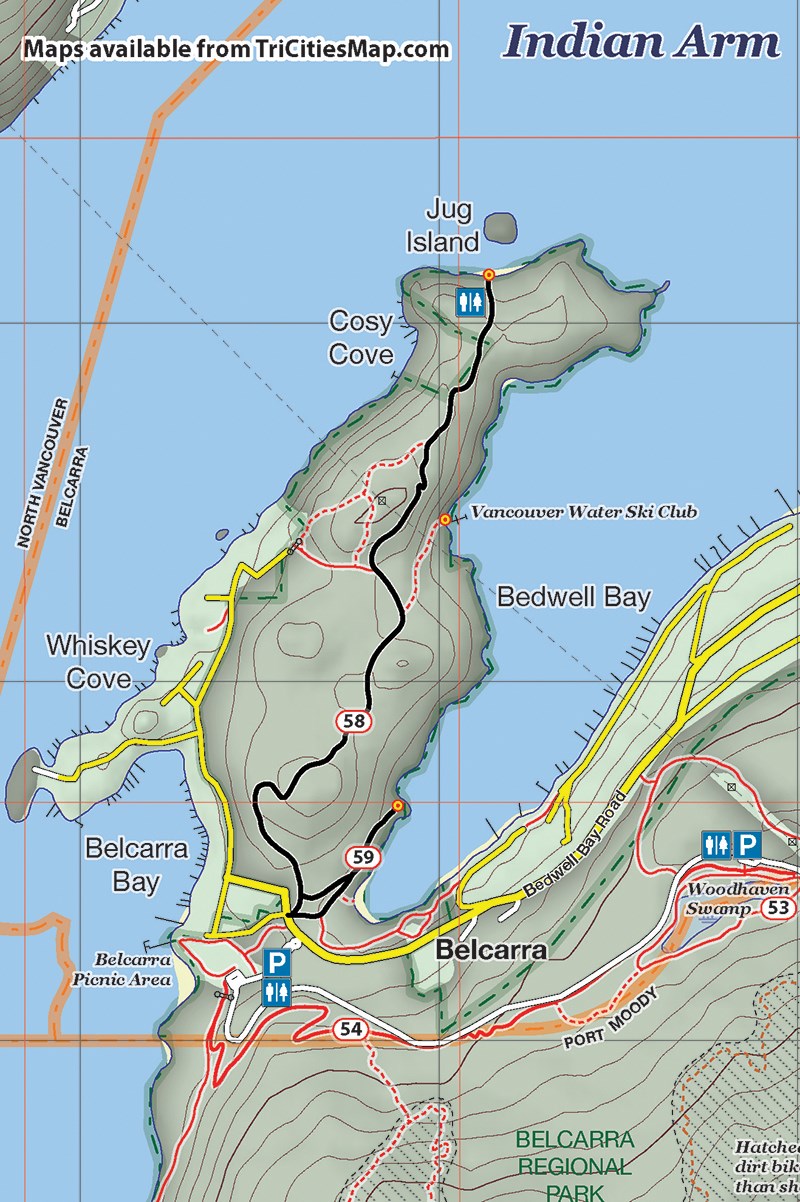
This easy walk, which starts and finishes from the Belcarra Regional Park picnic area, rewards the hiker with fine views down Indian Arm from the beach near Jug Island. Although the walk is far from flat, most of the steeper sections have wooden steps. Jug Island Beach is north-facing, so you will have to time your hike well to catch any sun there.
From the parking lot, head by the picnic shelters and pick up the short wooded path the other side. This will bring you out onto Bedwell Bay Road. Cross over this to pick up the trails on the other side, and take the trail that is sign-posted “Bedwell Bay Trail.”
After about 100 m, you will reach another trail junction where you will head left (north). The path follows the shoreline for about another 300 m before emerging at a nice viewpoint near the water overlooking Bedwell Bay.
(The deep waters of the bay are popular with divers as there are several shipwrecks located there. The west shore is also the location for the Vancouver Water Ski Club.)
Retrace your steps to an obvious fork in the path that you would have passed on the way, and take the other (right) fork. This will soon bring you out on the Jug Island Trail. Turn right and follow this trail all the way to Jug Island.
There are a few ups and downs along the way, with some short, moderately steep sections, but overall, the going is fairly easy. The steepest pitch is just before the beach, where a conveniently located outhouse is situated.
For the return journey, retrace your steps, ignoring the trails that lead off to the Bedwell Bay Trail. Another alternative is to take the track that heads west about 1 km from the beach. This leads back to the end of Bedwell Bay Road and provides a more urban (but faster) return to the parking lot. The picnic area has a concession stand and boat rentals in the summer, and year round barbecuing facilities.
--Steve Chapman is a Coquitlam Search and Rescue volunteer, a member of the Burke Mountain Naturalists and the creator behind a detailed new map of Tri-City trails. More info on safe hiking: www.coquitlam-sar.bc.ca.


