Hike of the Week
White Rock Lookout
Rating: strenuous
Time: 6 to 7 hours
Length: 10.5 km
Elevation gain: 1,020 m
The climb up the Halvor Lunden Trail is a really good workout, comparable to the Grouse Grind in both steepness and elevation gain.
The majority of people heading up this trail make their way to the cluster of lakes on Eagle Ridge or venture further to Lindsay Lake. Whilst these are worthwhile hiking objectives, they are currently under several feet of snow.
This alternative hike takes in the White Rock Lookout, a spectacular viewpoint with a vast open panorama stretching from Mt. Baker to downtown Vancouver and beyond to Vancouver Island.
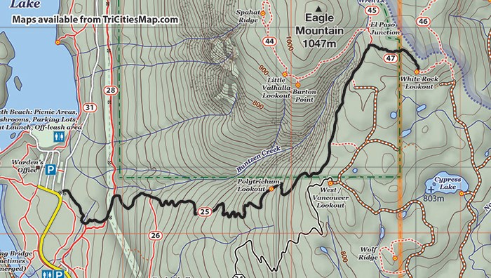
Start from the main parking area at Buntzen Lake and make your way to the service road that runs behind the parking lots. The Halvor Lunden Trail starts just past the locked gate ascending to the east.
Follow the trail for about half a kilometre over a stream, ignoring a trail coming in from the right. After emerging onto the Academy Trail under the power line clearing, head north on that trail for about 150 m, looking out for the continuation of the Lunden Trail. This heads up into the forest on your right and is the start of the trail proper.
The steep trail winds its way up the mountain on seemingly endless switchbacks. After about half a kilometre, there will be a trail heading off to the right. The trail goes to Eagle Bluffs, so ignore this and carry on with the ascent.
The main highlight of the climb is the Polytrichum Lookout just below the 700 m elevation mark. Once the trail begins to level out a bit at 800 m elevation contour, there is about another kilometre to go to the junction for the White Rock Trail. Expect the climb to that junction to take between two and three hours in total.
The White Rock trail is signposted with just a makeshift sign but the trail is fairly well flagged along the way to the lookout. After the junction, the trail ascends steeply where tree root ladders, mud and deadfall can all be expected.
After about 500 m, the trail levels out and then enters a clearing where the lookout can be seen just below. White Rock is a large, rocky outcrop with great views all around.
Be careful around the edges, which drop off steeply. Plan to spend time here to admire the view.
The easiest way back is to retrace the route up. The Halvor Lunden Trail is a very long and steep descent, so those with suspect knees should get out their walking poles.
An alternative descent is to head down on the path that continues east from the lookout, taking the service roads around the Upper Plateau to the Full Pull trail for the final descent. Currently, there is a lot of fresh blowdown on the top part of this route, however, making it a tricky option.
Steve Chapman is a Coquitlam Search and Rescue volunteer, a member of the Burke Mountain Naturalists and the creator behind a detailed map of Tri-City trails. More info: www.coquitlam-sar.bc.ca.


