Hike of the Week
Woodhaven Swamp
Rating: easy to moderate
Time needed: 3 to 4 hours
Length: 9.5 km
Elevation gain: 400 m
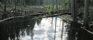
This hike takes in a figure of eight on well-defined and easy, graded trails, starting at Woodhaven Swamp and taking in both the picnic areas at Belcarra and Sasamat Lake. This man-made swamp was created during the area’s logging days and is now a fine wetland wildlife habitat.
From the parking lot at Woodhaven Swamp, head down the wooden steps to the lower path and then follow the path clockwise, passing over a small boardwalk bridge at the east end of the wetland. At the west side of the swamp, look out for a smaller trail that veers off on the left and follow that as it winds through the woods until it emerges out onto the main trail at the road side.
The main trail (Springboard Trail) is a cycleway that provides an off-road option for dropping down into the Belcarra picnic area. Follow this all the way down, taking the trail that runs behind (left of) the main parking lot at the recreation area. The trail crosses Bedwell Bay road and immediately forks. Take the right fork and then go right again at the next junction, following the trail that stays water side all the way to the road again.
Follow the road upwards and then turn left at the main road, following this for about a kilometre until you see a trail heading off on the right. The steep, rocky trail soon splits. Going right here will take you back to Woodhaven if you want to cut the walk short but our route heads left and upwards as it turns into a good track under the power lines. Near the top, you will see a signposted trail on the left. This will take you through forest towards the west side of Sasamat Lake.
Cross the road where the trail ends and continue on the path on the other side. This will bring you out on the trail that circulates Sasamat Lake near to the Outdoor Centre. Those with more energy can elongate their hike by walking the lake clockwise, adding 2.2 km and 70 m elevation gain. For those not doing that head south along the lake’s edge to the location of the pit toilets (near the floating bridge), where you should take the trail that heads up to the road. Follow the road to the T-junction and then turn right onto the gated road. At the hairpin, rejoin the Springboard Trail, following this all the way back to the parking lot at Woodhaven.
--Steve Chapman is a Coquitlam Search and Rescue volunteer, a member of the Burke Mountain Naturalists and the creator behind a detailed new map of Tri-City trails. More info on safe hiking: www.coquitlam-sar.bc.ca.


