HIKE OF THE WEEK
Lindsay Lake Loop
Rating: strenuous
Time needed: 6 to 8 hours
Length: 14.5 km
Elevation gain: 1,200 m
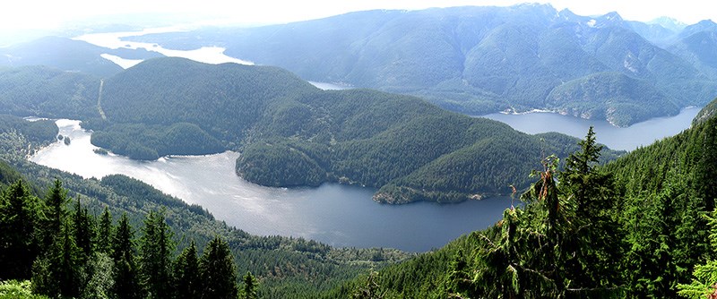
The Lindsay Lake Loop is a classic outing following a high loop on the upper reaches of Eagle Mountain, on the east side of Buntzen Lake. The steep climb up the Halvor Lunden Trail will be a stern test of your fitness but the top loop provides ample rewards in the form of lovely sub-alpine lakes and fine viewpoints overlooking Buntzen far below.
Start from the main parking area at Buntzen Lake and make your way to the service road that runs behind the parking lots. The Halvor Lunden Trail starts just past the locked gate, ascending to the east.
Follow the trail for about half a kilometre over a stream, ignoring a trail coming in from the right. After emerging on to the Academy Trail under the power line clearing, head north on that trail for about 150 m, looking out for the continuation of the Halvor Lunden Trail. Follow this all the way to the well marked “El Paso” junction. Expect the climb up to El Paso to take at least a couple of sweaty hours.
Take the trail that heads north from the junction. The other trail, which heads down into the gully, will be your return route. You will soon arrive at Eagle Mountain’s “Lake District,” a collection of small sub-alpine lakes in a marshy area. On your way north you will pass by Wren, Siskin, Robin and Demelza lakes.
This area is confusing as the path twists and turns with multiple junctions, and the signs are in a state of disrepair. If you follow trail options veering right, you will eventually end up on the trail heading north to Lindsay Lake. There is another stiff climb up to Lindsay Lake, at which point you will loop round the north end before returning south on the west side of the loop. Do not take the path that heads north from the top end of the lake as this continues along the ridge top towards Swan Falls.
Heading down quite steeply, you will soon come to the first of three spectacular viewpoints (“The Pulpit”) that look down onto Buntzen Lake and beyond.
After the last of the viewpoints, the trail continues down for about another kilometre until you reach a trail junction.
Either fork will take you home but the right fork is recommended as it takes you over w Ridge, a rocky outcrop with yet more fine views.
From Spahat, the trail contours south around Eagle Mountain, taking in another couple of viewpoints along the way (Little Valhalla and Barton Point). The last section of this trail drops down into Buntzen Creek before ascending back up to El Paso and completing the loop.
Follow the same route you came up back to the parking lots at Buntzen Lake. At the end of a long day, this descent will seem like a very long way — hiking poles are recommended to save the knees.
--Steve Chapman is a Coquitlam Search and Rescue volunteer, a member of the Burke Mountain Naturalists and the creator behind a detailed new map of Tri-City trails. More info on safe hiking: www.coquitlam-sar.bc.ca.


