Rating: Moderate/strenuous
Time Needed: 6-8 hours
Length: 13.5 km
Elevation gain: 950 m
The traditional Diez Vistas hike is named for the 10 viewpoints that overlook the Indian Arm side of the ridge. Most people doing the hike will take in the South Beach Lookout also.
This week’s hike adds in a 12th, seldom-visited viewpoint on the north end of the ridge. With the exception of that last vista, the trails are well marked — but expect a long, strenuous hike.
Start at the main Buntzen Lake parking lot and take the main trail that heads south from the southwest corner of the parking lot. Follow the main trail to the floating bridge, after which you will come to a four-way junction with a major track. Cross directly over this, taking the trail opposite the bridge. This is the start of the Diez Vistas trail and it will lead you up to the saddle between the Diez Vistas Ridge and Sugar Mountain.
The tree cover opens up near the saddle (with views) and you will need to cross straight over two other trails and pass by an old pipeline to continue on the correct route. After a short traverse, the climb will start in earnest up to the top of the ridge.
At the first trail junction, be sure to take the left option as right takes you on the old trail and tricky ground. At the second junction near to the top, head right, after which it’s just a short distance to the South Beach Lookout. From the lookout, continue north on the main trail. A trail coming in from the left (do not take it) marks the last of the trail choices for a while.
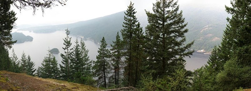
The Diez Vistas trail heads generally in a north direction and has a lot of ups and downs, with steep sections of rock and tree roots. These require care to pass safely. This section of trail has 10 viewpoints (or vistas) along the way, some of which are really nice, but others are somewhat mediocre. Generally, the southern viewpoints are the better ones. Sharp eyesight is sometimes required to find the vista signs to confirm where you are.
The long downhill starts after Vista #10. The trail will take you all the way down to the BC Hydro road. About a third of the way down, the trail intersects an old decommissioned skidder road. Here it is necessary to turn right (and then shortly afterwards left) to stay on the proper trail. About 200 m before reaching the service road at the bottom, look out for a fairly indistinct (flagged) trail going off to the left. For those wanting to tick off the 11th vista, follow this steeply upwards.
After cresting the ridge and a short downhill, you will come to the viewpoint. From here, continue steeply down the other side to the end of a service road.
Follow this (keeping right at the junctions) all the way to the usual trailhead for the Diez Vistas trail.
Continue southeast on the track and when you reach McCombe Lake, take the path southeast to the junction with the Buntzen Lake Trail. Cross over to the North Beach via the suspension bridge and then follow the trail along the east side of Buntzen Lake all the way back to the parking lot. Note that the trail to the 11th vista is a new addition on the second edition of the trail map.
Steve Chapman is a Coquitlam Search and Rescue volunteer, a member of the Burke Mountain Naturalists and the creator behind a detailed new map of Tri-City trails. More info on safe hiking: www.coquitlam-sar.bc.ca.
hike-map


