Munro & Dennett Lakes
Rating: moderate
Time needed: 6-7 hours.
Length: 11 km
Elevation gain: 1,100 m
The hike to Munro and Dennett Lakes is a fairly strenuous workout, but your efforts will be rewarded with fine sub-alpine lake scenery when you reach the upper plateau of Burke Mountain. A more detailed description of this hike can be found in Burke and Widgeon – A Hiker’s Guide by Lyle Litzenberger.
The trail starts off Quarry Road, 3 km further on from the parking lot for Minnekhada Regional Park. Look out for a rocky path going up on your left opposite a pull-in on the side of the road. Parking at this trail head is roadside only. Follow the track upwards for 250 m and then take the trail that forks off to the right.
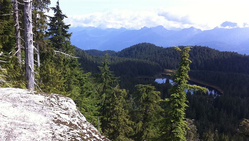
The trail now climbs more steeply as it switchbacks up towards the upper plateau. The trail is well defined but in some of the more open areas the path sides may be grown in a little. At the 500 m mark there is a viewpoint just off the main trail, but there is a better viewpoint at the 700 m mark. This requires a short detour (out and back) on the left branch where the trail splits.
The climb is a long one, but after 800 m the trail will begin to flatten out and you will soon arrive at a complicated four-way junction.
The way straight ahead is the old trail to the lake and is now decommissioned, so take the trail that goes right to Munro Lake. Half a kilometre of undulating terrain will bring you out on its marshy shores. The lake was dammed in the past, but now the lower water levels allow you to pass to the other side via a raised strip of land over to the north side.
The trail now begins to climb steeply again up towards Dennett Lake. As the trail flattens out and becomes wet and marshy, look out for a side trail on the left. The junction is about 800m from Munro Lake. The side trail takes you to the Munro Lake Lookout, a spectacular viewpoint that looks down onto Munro Lake and beyond. This is a good spot to take lunch.
After completing this “out and back” it’s just a short distance until you reach the shoreline of the more well-defined Dennett Lake. It is possible to retrace your steps here for the return journey, but a more interesting variation is to head southwest along the lake shore for about 150 m and then take the trail that forks south from there (the main trail will take you up onto Burke Ridge). The route takes you through pleasant open meadows, but is very wet so waterproof footwear is recommended.
After about a kilometre you will intersect with the Village Lake Trail, one of the more significant trails on the mountain. Turn left and follow this for 1 km to the four-way junction where you should retrace your tracks down the Munro Lake Trail to the road. Be careful to pick up the correct path down at this point (there are some basic signs) as an error here could lead you onto some tricky and steep terrain.


