Burns Road north of Dominion Avenue is now open to single-lane alternating traffic during work hours, and two-way traffic at other times, according to an update from the City of Port Coquitlam.
The partial opening follows a three-week closure that was necessary for workers to continue important flood protection upgrades in northern PoCo.
Still, pedestrians and cyclists are encouraged to avoid the area while active construction takes place.
Drivers are also encouraged to take alternate routes, if possible, to avoid delays and driving on unpaved roads.
Two-way traffic, round-the-clock, is expected to resume in October, and project completion is anticipated for November.
“Burns Road remains a construction zone but we can now offer some limited access for residents, businesses and emergency vehicles travelling through the area,” Mayor Brad West said in a press release.
“We thank everyone for their patience and cooperation as this work continues. We just need to think back to the extreme rain and storms of last fall to point out the importance of this project and the significant investments Port Coquitlam is making to protect the community from flooding.”
Road users are asked to follow all instructions and detours.
The public is encouraged to check out an interactive map showing the road closure.
The roadwork is necessary to allow the installation of a large culvert — part of the city's drainage system and a critical piece of infrastructure that serves most of eastern Port Coquitlam, and drains into the Pitt River.
It has deteriorated over the years and required temporary repairs in 2019 and earlier in 2022, the city states.
Failure of the culvert would have caused significant flooding, causing damage to private and public property and infrastructure as well as creating major safety concerns.
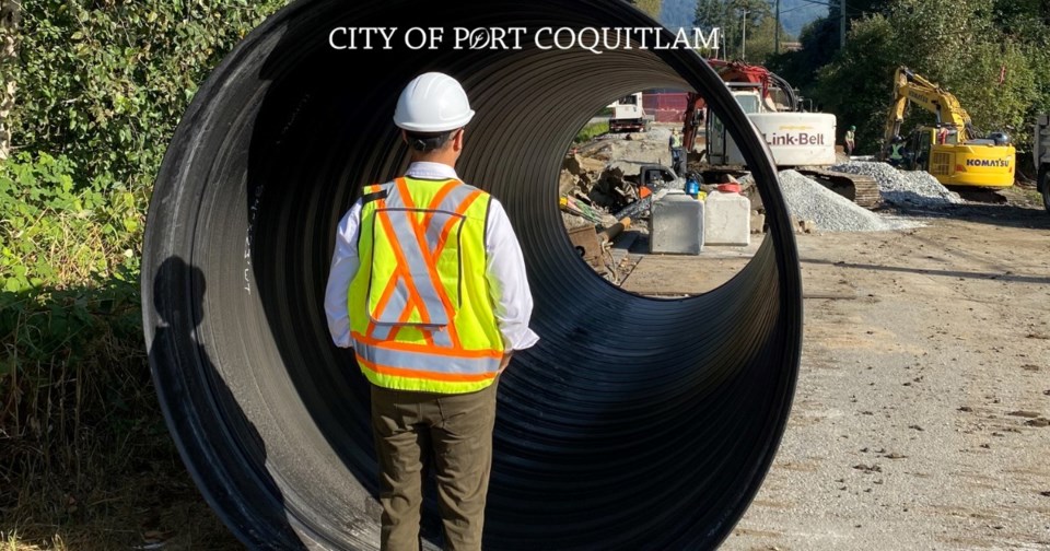
Work on the replacement project began in late August and is proceeding on schedule. The contractor has now removed the old culvert and is in the process of installing a new culvert – with a diameter of 2,100 mm tall enough to walk through.
Featuring a fish-friendly design, the new culvert’s larger capacity will accommodate increasing rainfall intensities and creek volumes.
“Adapting to climate change is now a key consideration as we plan and budget for capital projects,” noted Coun. Darrell Penner, council’s designate for public works matters.
“For this project, it was important to not just replace the culvert but to ensure the new infrastructure will stand up to the impacts of increased rainfall and storm intensities in the years to come.”
Heavy rainfall and winter storms in recent years have advanced the need to construct a number of culvert, pipe and pump station upgrades. Replacing the Burns Road culvert is a critical upgrade prior to the upcoming winter season and storm events, the city says.
Other flood protection projects planned in the coming months include replacement of the Fremont/Handley culvert, new pump stations at Maple Creek and Cedar Drive, and Wellington Avenue sanitary sewer and storm main upgrades.
The city has more details about these and other projects in its capital plan.
Funded through capital reserves
Flood-protection infrastructure is funded through various capital reserve accounts, and the city also actively seeks out and plans around available provincial and federal infrastructure grant funding to reduce the burden on taxpayers.
Much of Port Coquitlam is located in the flood plains of the Fraser, Pitt and Coquitlam rivers.
The various flood-protection measures protecting these areas — including infrastructure like dikes and pump stations, and a BC Hydro agreement controlling flows on the Coquitlam River — have been developed and maintained to withstand what has historically been considered the 1-in-200-year flood level, in keeping with direction from the provincial government.
The city also conducts a variety of other activities to reduce flooding risk, including managing stormwater and inflows of excess water to the sewer system, assessing and repairing the city’s drainage system (including pipes and culverts), and upgrading aging infrastructure.


