Don't worry, there's no heat wave expected for the Tri-Cities over summer's final three-day weekend.
In fact, it may be quite the opposite.
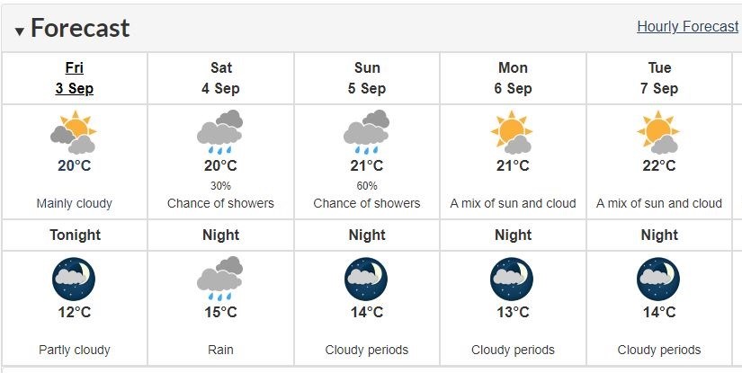
Environment Canada says underwhelming conditions are on the docket over the Labour Day long weekend with rain in the forecast for Sunday (Sept. 5) at a 60% chance across Coquitlam, Port Coquitlam, Port Moody, Anmore and Belcarra.
Frequent afternoon precipitation is also expected at a 30% chance for Saturday (Sept. 4) amidst cloudy skies.
However, with temperatures predicted to reach the low 20s, sunnier conditions are on the horizon for Monday (Sept. 6) and could stay the same for the first week back to school.
For fall 2021, Environment Canada meteorologists are calling for a warmer-than-average season for B.C.'s south coast.
The winter La Niña could also impact temperatures in the Lower Mainland, as well as the amount of snow.
Currently, the federal weather forecaster's models are indicating that there is a "medium" chance of a weak La Niña this winter but that its effects won't show until December.
2021 — METRO VANCOUVER'S SECOND HOTTEST SUMMER
In 63 years of records, no summer across Metro Vancouver has packed such scorching temperatures as this one did.
According to Environment Canada, summer 2021 was the second hottest ever recorded. To find a hotter summer, you have to go back to 1958 — the year NASA was founded and the plastic hula hoop and instant noodles hit shelves for the first time.
The daily average temperatures at Vancouver International Airport hit 18.9 C for June, July and August, only 0.2 below the 63-year-old record but well over the 17.2 C normal.
Usually, June is what Environment Canada meteorologist Armel Castellan calls a “troughy month,” with plenty of low-pressure systems offering rain and lower temperatures across much of B.C.
But this June bucked that trend when a one-in-a-thousand-year heat dome settled over the province, shattering all-time temperature records in over 50 communities. The high temperatures kept coming, with two more heat waves hitting the province in July and the early days of August.
Those soaring temperatures can’t be separated from the extended drought and extensive wildfire smoke that continues to affect huge swaths of B.C.
“Temperature was the headline of the summer. The health impacts were so devastating,” says Castellan. “But they’re linked.”
“Smoke is a result of drought, is a result of these high temperatures.”
Environment Canada started seeing precipitation fall off early in 2021. With spring came the drought, setting the stage for blistering temperatures, wildfire and smoke that drifted across the continent as far as New York City.
Castellan says communities like Victoria, Abbotsford and Kelowna saw about a third of their normal precipitation.
It’s all part of a trend moving the province toward huge swings in seasonal extreme weather.
At a regional level, climate models predict B.C. will see more precipitation fall in extreme events in the winter, with hotter, drier conditions dominating the summer.
“We know those patterns are shifting,” says Castellan. “The drought drives this type of storyline.”
- with files from Elana Shepert, Vancouver Is Awesome, and Stefan Labbe, Glacier Media


