New markers are going up along the Traboulay PoCo Trail starting this week to allow users and visitors to easily pinpoint their location when calling 911.
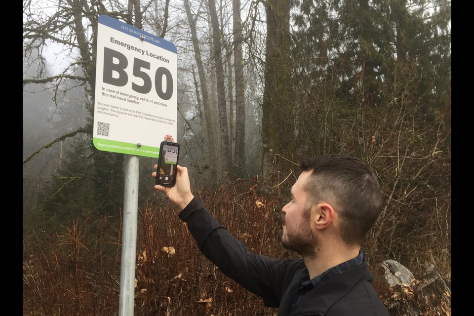
A project of Port Coquitlam Fire and Emergency Services (FES), and a first in the Tri-Cities, the 14 new signs at key trail entry points will feature both a location code known by area emergency responders, and a QR code to a map showing the location.
Members of the public are encouraged to take note of the marker number when they enter the trail and can use the QR code to get to a landing page that shows where they are.
The letter and number — corresponding to access points across four zones — would be used in an emergency to tell 911 dispatchers where a fire, medical health issue or other problem is occurring.
Port Coquitlam’s fire truck computers have also been updated with detailed information about each code’s location, such as obstacles or any hazards.
"We completely developed it," acknowledged Chief Robert Kipps, who said police, fire and paramedics all know the numbered reference points and will be able to more quickly get to the scene along the trail's 25-kilometre loop.
The idea was the brainstorm of the city's fire suppression team who responded to as many as 45 bush fires in 2021, many of them alongside or in view of the trail system.
As well, PoCo fire and paramedics are often called to medical emergencies along the trail.
On hand for a recent demonstration of the trail marker system were members of Fire Medic 2, including Kevin Masi, Jaydon Hamilton and Riley McLeod, who would be among the members of the team responding to calls on the north side of the city along the trail near Hyde Creek Recreation Centre.
Kipps said the plan is to eventually install coded trail markers at access points along every trail.
"It will grow as needed," he said, noting the project is "scaleable" so it can be expanded throughout the city.
Mayor Brad West was also on hand to show how one can easily use the QR code to get the map; the landing page will also include important emergency information, such as trail closures or even a bear in the area.
"This is just a real innovation and common sense way to add to the work fire and emergency services are doing to keep people safe," West said.
The program has already received kudos from people in the community, West said, especially seniors.
"If they need to they can really quickly connect if they need help in an emergency," he said, "It's a really positive thing."
The new trail marker system is also an acknowledgement that since the pandemic more people are using the local paths — which traverse a varied ecosystem of forest and creek, meadow and marsh, riverfront and urban development.
The program began as part of Port Coquitlam’s wildfire preparation efforts, which includes participating in a half-million dollar regional BC FireSmart grant.
It will be expanded as funds allow.
Trail and project information, including a map showing the location codes, can be found on the City of Port Coquitlam's website.


