Some Tri-City residents may find themselves in a new federal riding when they go to the polls for the next federal election.
Last week, the Federal Electoral Boundaries Commission for B.C. came out with a proposal to redraw the lines for constituencies, including Coquitlam–Port Coquitlam and Port Moody–Coquitlam.
B.C. and Ontario are set to gain one more federal seat each as a result of population changes, as shown in the 2021 Census, while Alberta is expected to have three more seats in the House of Commons.
Starting June 6, the commission will hold 27 public hearings across the province to gather feedback on its planned realignments.
In the Tri-Cities, the hearing is set for Sept. 27 at 7 p.m. at the City Centre branch of the Coquitlam Public Library (1169 Pinetree Way).
Coquitlam–Port Coquitlam Liberal MP Ron McKinnon told the Tri-City News today (May 11) the commission’s recommendations "make no sense" and he’ll be advocating for an alternative.
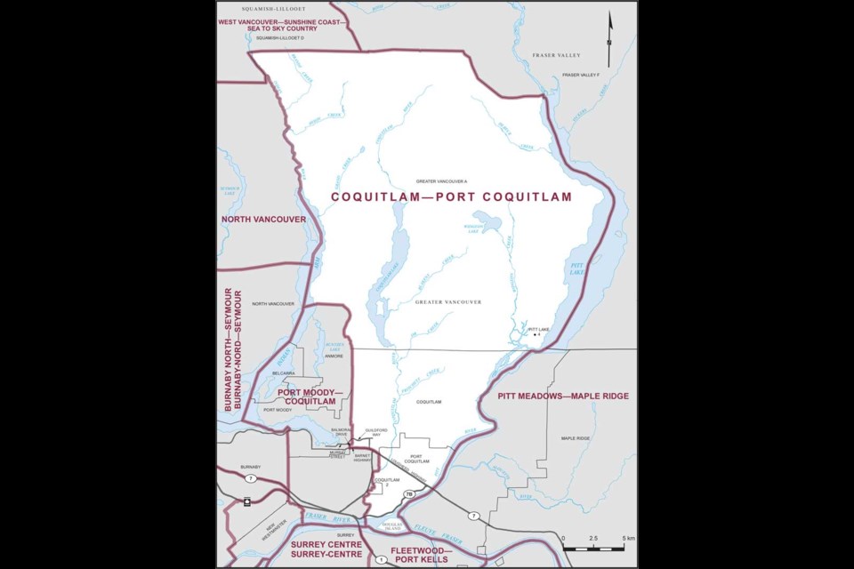
Currently, Coquitlam–Port Coquitlam is made up of the following:
- City of Port Coquitlam
- East of Indian Arm and the Indian River
- Pitt Lake Indian Reserve No. 4
- Coquitlam, north of Highway 7A (Barnet and Lougheed)
- Coquitlam Indian Reserve No. 2
But under the commission’s plan, the federal riding would consist of, in general:
- Port Coquitlam, north of Lougheed Highway
- East of Indian Arm and the Indian River
- Coquitlam, north of Highway 7A (Barnet and Lougheed)
- Coquitlam, south of Highway 7A (Barnet and Lougheed) including the neighbourhoods of Ranch Park and Riverview Heights, plus Colony Farm Regional Park
As a result, Port Coquitlam residents living south of Lougheed — including the downtown and the Mary Hill and Citadel Heights neighbourhoods — would fall in the Pitt Meadows–Fort Langley electoral district.
"The recommendations recently proposed by the Electoral Boundaries Commission make no sense," McKinnon said.
"Severing Port Coquitlam in two and combining it with Fort Langley, parts of Surrey, Pitt Meadows and Maple Ridge is not workable."
McKinnon fired a letter to Port Coquitlam Mayor Brad West, Maple Ridge Mayor Mike Morden and Pitt Meadows Mayor Bill Dingwall on the same day the proposals were made public on May 2.
As for Port Moody–Coquitlam, its current makeup is as follows:
- Coquitlam, south of Highway 7A (Barnet and Lougheed)
- City of Port Moody
- Coquitlam Indian Reserve No. 1
- Villages of Anmore and Belcarra
- Part of the northern shoreline of Burrard Inlet in Port Moody
- Boulder Island
Under the commission’s plan, the proposed federal riding would be, in general, west of Mariner Way in Coquitlam and include the City of Port Moody, Anmore and Belcarra, plus part of the Burrard Inlet shoreline and Boulder Island.
“Right now, I am listening to and consulting with residents," MP Zarrillo told the Tri-City News. "Our riding is one of a few in the area that will see change, and I am looking forward to hearing what the community thinks.”
According to a release, the changes to B.C.’s federal electoral district boundaries came through an independent, non-partisan process from the commission members: The Hon. Justice Mary Saunders (chair); R. Kenneth Carty; and Stewart Ladyman.
"Our task is to create an additional riding and to adjust the boundaries of existing ridings to maintain effective representation for all British Columbians," stated Saunders.
The Canada-wide redistribution is expected to be done by September 2023.
The next federal election is due to be held on or before Oct. 20, 2025.
Here’s how you can have your say at the commission hearing on Sept. 27 in Coquitlam:
- Website: redistribution2022.ca
- Call: 855-747-7236/ 1-800-361-8935
- Email: [email protected]
- Mail: Secretary, Federal Electoral Boundaries Commission for B.C., 300–1055 West Hastings St., Vancouver, B.C. V6E 2E9


