It appears meteorologists are seeing some snowy conditions in the forecast for the Tri-Cities.
The good news: it's likely not to stick around.
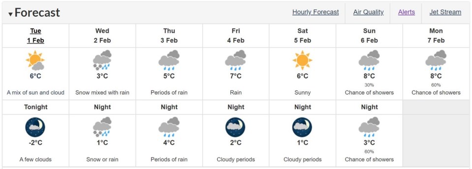
Up to five centimetres of the white powder is currently predicted to fall on Coquitlam, Port Coquitlam, Port Moody, Anmore and Belcarra tomorrow (Feb. 2), according to Environment Canada.
And there may be more snow at higher elevations like Burke Mountain and Westwood Plateau.
The national service, in a special weather statement, explains a Pacific frontal system is making its way to B.C.'s coast with temperatures hovering around zero degrees.
"Freezing levels will initially be near sea level Wednesday morning and as a result precipitation will start as snow," an alert reads. It was put in place just before 2 p.m. today (Feb. 1).
Environment Canada is forecasting cloudy skies for most of Wednesday, noting the snow may be mixed with rain by the afternoon rush hour and into the night.
Commuters are being asked to be prepared for snowy roads by adjusting driving habits to potentially slicker conditions.
Thursday (Feb. 3) is expected to see long periods of rain from dawn to dusk with the mercury expected to reach a high of 5 C.
If the snow flies, it'll mark the first time in about a month that the Tri-Cities will have seen any significant snowfall.
Nearly 20 cm of snow fell on the region the early morning of Jan. 6, forcing schools to close and city crews to get out on the roads quickly to clear priority routes.
Even Port Coquitlam Mayor Brad West joined his municipality's workers to witness first-hand what it takes to ensure the safety of residents.
"A lot of skill and care to navigate side streets with cars parked on both sides," he said of the experience.


