Fresh powder is on the way for the Tri-Cities — and it could be widespread and unexpected.
That's according to Environment Canada as the national service has issued yet another snowfall warning for Coquitlam, Port Coquitlam, Port Moody, Anmore and Belcarra ahead of the New Year's Day long weekend.
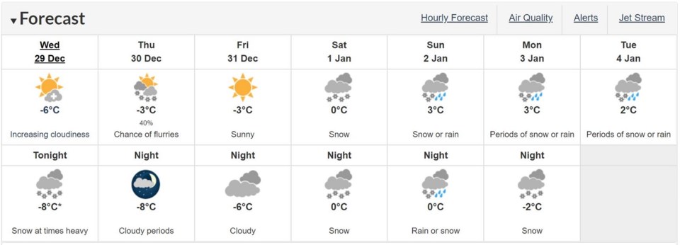
As of 8:26 a.m. today (Dec. 29), up to 10 cm of snow could accumulate by tomorrow morning (Dec. 30), especially at higher elevations in the Lower Mainland, Metro Vancouver and Fraser Valley.
Meteorologists explain, in a statement, a system is moving across the south coast towards inland sections, bringing in ample cold air in the process.
"The current forecast suggests widespread 5 to 10 cm of snow is likely," the warning says.
"However, there is the potential for locally heavier amounts particularly over the Sunshine Coast, North Shore Mountains, and parts of Vancouver Island. Most regions will see close to 5 cm accumulate rapidly within 3 to 6 hours during the overnight hours when the snowfall will be most intense."
Reminder: Clear snow and ice from windows, lights, mirrors, hood and the roof before you drive. https://t.co/9mzy1KZgus
— Mainroad Contracting | Shift into Winter (@MainroadLM) December 29, 2021
Check @DriveBC and drive with caution #ShiftintoWinter #BCStorm pic.twitter.com/nN2sgnNiZ4
Motorists are being encouraged to slow down during snowy conditions as visibility may be suddenly reduced in areas with heavier snow.
There are currently no obstructions or closures on local roads or highways as of this publication.
Meanwhile, an arctic outflow warning could end at some point today or tomorrow morning as temperatures continues to hover near or below -20 C with wind chill across the Tri-Cities.
The alert still warns of the possibility for frostbite and hypothermia if adequate precautions are not taken when outdoors, and Environment Canada recommends minimizing exposed skin with hats, scarves and mittens or gloves.
The current forecast is calling for sunny skies with a high of -6 C, but will feel like -10 C as winds gusts up to 20 km/h in the afternoon.
Most of Thursday is predicted to be mainly cloudy coupled with 15 km/h winds. The snow is expected to taper off in the morning and the sky to clear up by the late afternoon.
As for New Year's Eve (Dec. 31), places like Coquitlam, Port Coquitlam and Port Moody will see sunshine to begin the weekend at a high of -3 C.