As the weather warms up, there’s nothing better than to get out on the trails and enjoy the fresh air.
However, it’s still very much winter on the higher slopes, so until the snow melts out later in the summer, it’s best to stick to the lower trails.
The hike described here highlights a local “all season” hiking option.
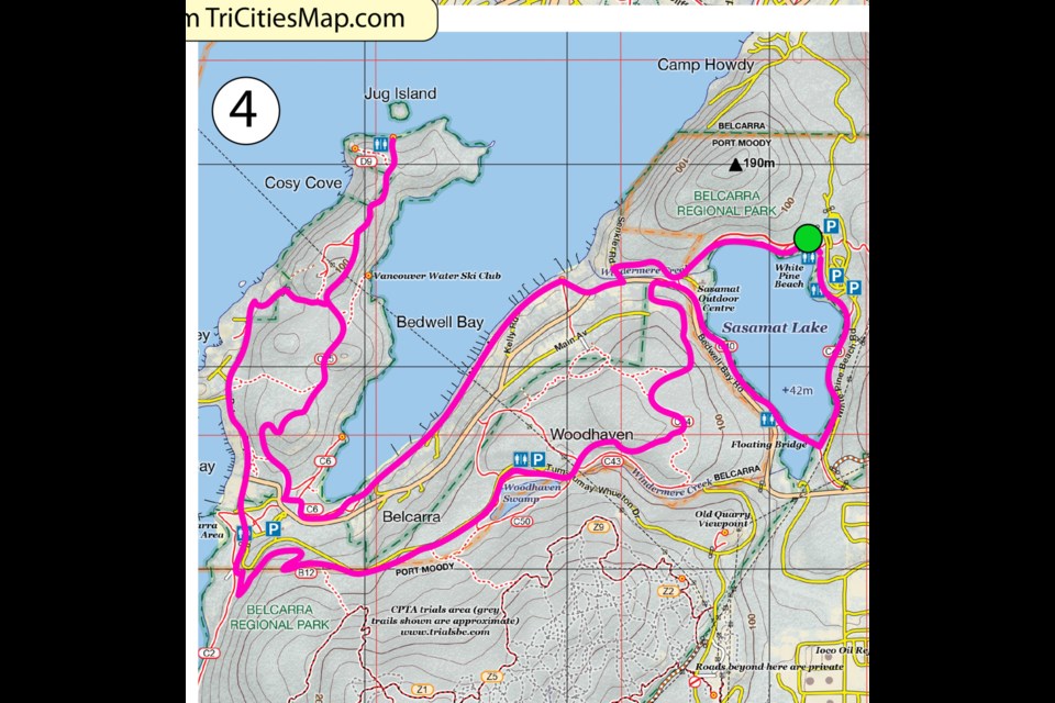
Bedwell Bay–Jug Island–Woodhaven Loop
18 km
540 m ascent
This four- to five-hour loop has a lot of nice viewpoints over Bedwell Bay, Indian Arm and Sasamat Lake. It’s a long hike but mostly over easy terrain.
From the concession stand at White Pine Beach, head west on the paved trail and then veer off left onto the gravel lakeside trail.
This will eventually take you up to a gravel road where you will turn left.
Follow the gravel road past the gate all the way out to Senkler Road, which you will follow out to the main road just after the bridge.
Follow Bedwell Bay Road a short distance west before cutting down Watson Road and a short trail down to the water.
Now, follow Marine Avenue along the water’s edge for over a kilometre, enjoying the fine views of Bedwell Bay along the way.
There’s a short section of trail bridging a gap in the road.
Eventually you will hit the start of the Bedwell Bay trail, which you will follow past a “fork and join” for about half a kilometre to a trail junction.
Go left at the junction out to the road and the start of the Jug Island Trail.
Now follow the well-signposted Jug Island Trail all the way to the end (about 3 km) to the spectacular viewpoint overlooking the island.
On the way back, just after descending the large run of steps, turn right onto the wide trail that heads west out onto Coombe Lane.
Follow the roads south now all the way to Belcarra Picnic Area.
Pick up the trail on the left side of the concession stand (Admiralty Point Trail) and, shortly after, veer onto the Springboard Trail.
This switchbacks for some considerable distance, eventually taking you to the north side of Woodhaven Swamp before emerging out onto Tum-Tumay-Whueton Drive.
Take the second right after the zebra-crossing onto the Woodhaven Trail. Follow this for almost 2 km, eventually emerging onto Bedwell Bay Road again.
Cross over the road and go down the steps, following the trail to a bridge, which marks the intersection with the Sasamat Lake Loop Trail.
At the bridge, turn right, completing the loop back to the concession stand via the floating bridge.
Tired legs, however, might want to turn left here and retrace the outgoing route back to the start.
Coquitlam SAR Safety Tips: (3 T’s)
TAKE “THE ESSENTIALS” and other necessary equipment:
- flashlight with spare batteries
- extra food and water
- paper map/compass/GPS
- emergency shelter
- signalling devices (whistle, air horn, phone)
- extra clothing (to survive a night out)
- first aid kit
- pocket knife
- fire starter
- bug repellant/sunscreen
TRAIN: Make sure that you and the people you are hiking with (never go alone) are in good enough physical shape to do the hike comfortably and are also mentally prepared. Everyone should have the travel skills needed for the route. You should fully research your route beforehand and check the weather forecast.
TRIP PLAN: Make sure someone will come to look for you if you don’t return, by providing a trip plan to a responsible person who will raise the alert (i.e., call 911). The trip plan can be on old-fashioned paper or in electronic form. To create an online trip plan use the AdventureSmart App or the Overdue App (with maps).
Please consider donating to Coquitlam Search and Rescue in its 50th year. Go to coquitlam-sar.bc.ca to make a contribution.


